English
 Türkçe
About
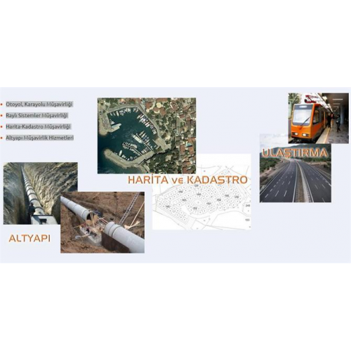
Our company, which was established in 1984; global scale, engineering
and consultancy sector photogrammetric map production, transportation,
in water resources, landscaping, coastal structures and other infrastructure projects
at the same time, under the single roof, on time and beyond expectations
offers holistic solutions.
Mescioğlu, successfully completed Turkey\'s \"first-Speed Train
Consultancy of \"Ankara (Esenkent) - Eskişehir Railway Rehabilitation
Project Construction Supervision and Consultancy Service Work,
Within the scope of Adana Light Rail System Project and construction consultancy
experience in both infrastructure and superstructure consultancy
has gained. Our company is currently TCDD Plant in 2018.
Malatya-Elazığ (YHT) tendered by the General Directorate,
Şanlıurfa-Mardin (YHT), Erzurum-Kars (YHT) and Siirt-Kurtalan
Railway Survey Project Engineering Services contracts
signed and its total length is approximately 550 km.
services, to project at high speed railway standards
continues.
70% of our country\'s photogrammetric map production potential, Mescioğlu
A.S. carried out under contracting. For example;
EU funding covering the whole of Turkey, \"Land Parcel Identification
Within the Scope of Digitization of the System, 1/5000 Scale
Creating Orthofto Maps ”(financed by the European Union
one of the world\'s largest sectoral investments), “Istanbul
1/1000 and 1/5000 by Photogrammetric Method within the City Borders
1/1000 Scale Orthophoto Map Production with Scaled Map \",\" Bursa
Within the borders of the Metropolitan Municipality and its immediate surroundings (12,500
km 2) 1/1000 Scale Photogrammetric Vector and 1/5000 Scale
Orthophoto Production (Physical and monetary production financed by domestic budget
the largest service procurement in the sector in terms of size) ”Projects
can be shown. In addition, our company has successful projects abroad.
continues to sign. “Kosovo
Aerial Photograph Acquisition and Orthophoto within Country Borders
Production of Maps \"Project was completed in 6 months